Current Conditions
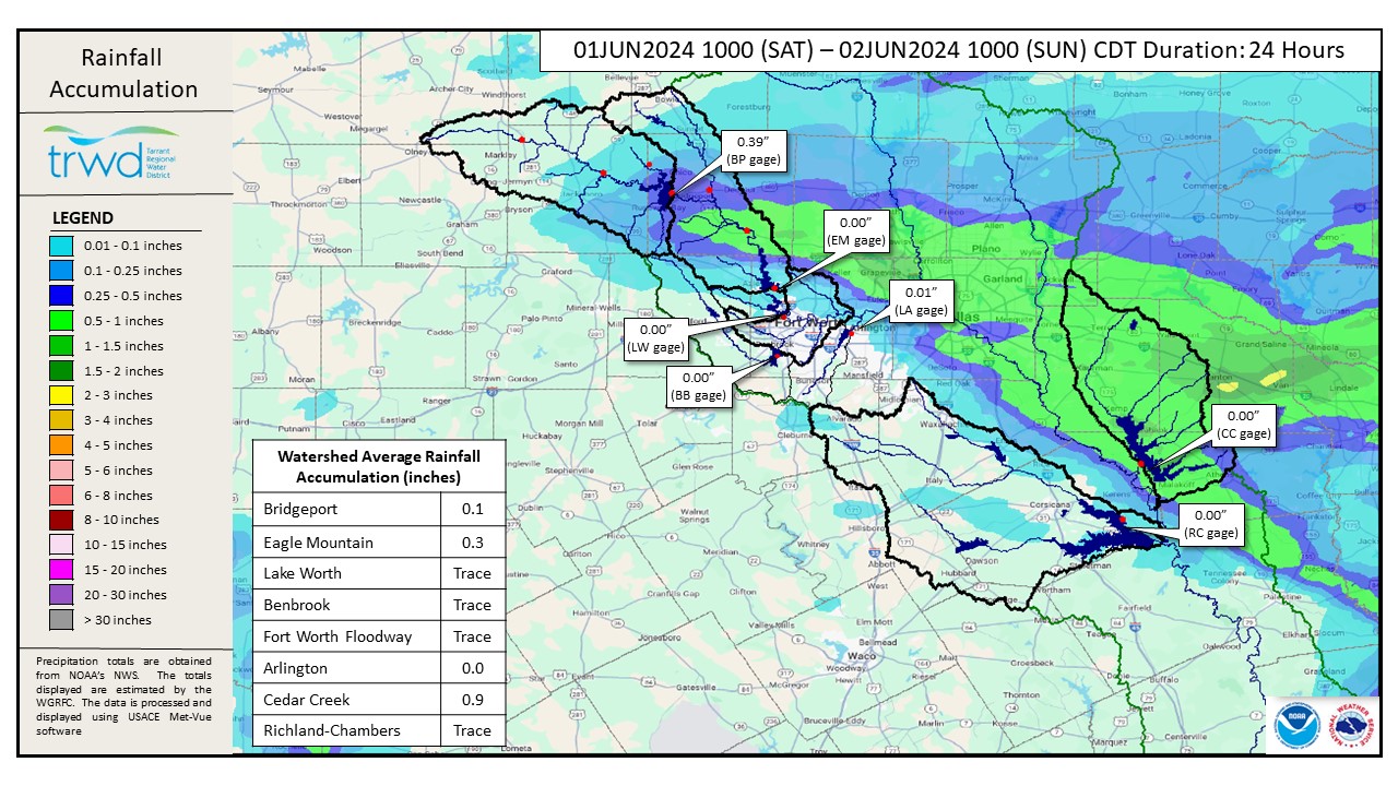
- Additional rain fell over parts of the West Fork watersheds (mainly Eagle Mountain; ~0.8″) and over Cedar Creek (~1″) in the past 24 hours. See Graphic-1 for rainfall totals.
- Flood discharges are ongoing at Eagle Mountain, Richland-Chambers and Cedar Creek.
Projections
- Lake Bridgeport
- The Jacksboro gage continues to increase and is currently projected to reach 3,000 cfs.
- Bridgeport will continue to rise the next few days.
- Latest projection for how high the pool will rise based on past rainfall is roughly 827 ft-msl.
- Eagle Mountain Lake
- The pool level has been trending downward.
- Spillway operations today will slow the rate of fall
- Barring additional rainfall, expect pool levels to remain fairly constant today.
- Cedar Creek Reservoir
- The pool peaked at about elevation 322.6 and is currently trending downward.
- Richland-Chambers Reservoir
- The pool level is increasing and is expected to continue increasing as flow from the Rice gage arrives.
- Barring additional rain, pool levels should crest under elevation 316.5 later this afternoon.
*Projections are subject to change and are based on past precipitation.
Looking Forward
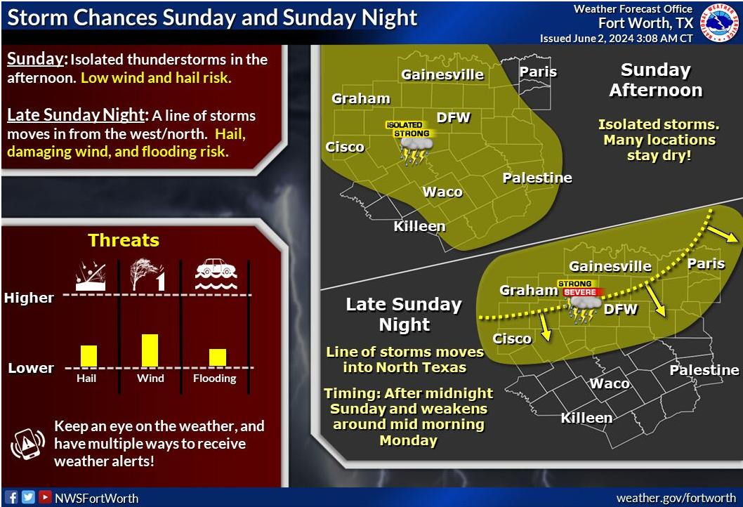
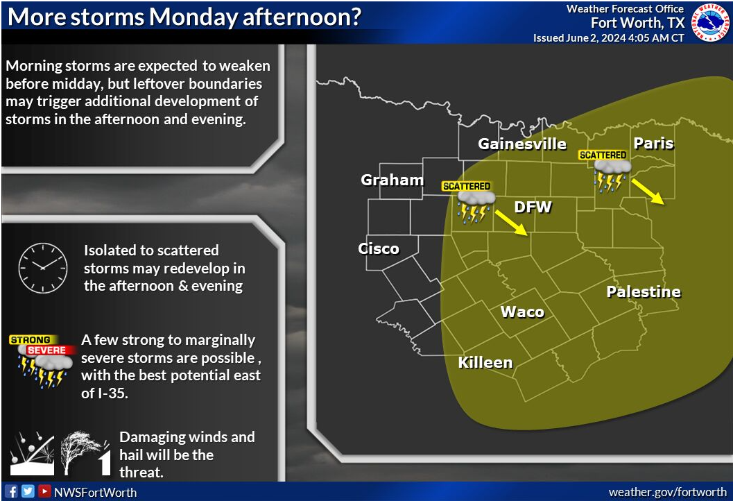
Additional isolated storms are possible today afternoon and evening. These storms bring threats of large hail, high winds and flooding, but rainfall depths are expected to be low. More rain is expected tomorrow as atmospheric conditions will favor the development of storms. See the latest NWS Guidance in Graphic-2. Bridgeport is more than 9 ft below conservation and has plenty of room to catch additional runoff. The other TRWD lakes are over full and discharging flood waters. TRWD staff will continue to monitor conditions and flood discharges will be adjusted accordingly.
Please stay weather aware and follow our partners at the National Weather Service (NWS) and the River Forecast Center (RFC) for the latest information regarding weather and river conditions, respectively.
Current TRWD lake conditions are shown below. Be sure to subscribe to receive e-mail notification of any new Lake Level Blog posts. You can also follow @TRWD_News on X (formerly known as Twitter) to receive Lake Level blog notifications.
Next update will come when conditions warrant. Please subscribe or check back when lake levels are on the rise.
Graphic-1. 24-Hour Rainfall Totals
Graphic-2. NWS Guidance
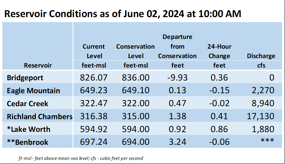
*Lake Worth is owned and operated by the City of Fort Worth. See the City of Fort Worth news feed and NWS forecast page for updates on Lake Worth.
**Benbrook Lake is owned and operated by the U.S. Army Corps of Engineers. ***See Benbrook Lake Home Page for current discharge.
Current lake levels can be found in a variety of locations including TRWD.com, the TRWD watershed data viewer trwd.onerain.com, or download the TRWD Lake Level App for iOS or Android.
Please call the Flood Hotline for further information.
817-720-4296
If prompted to leave a message, the flood monitor on duty will return your message within 30 minutes.
Posted by VdO.