Current Conditions
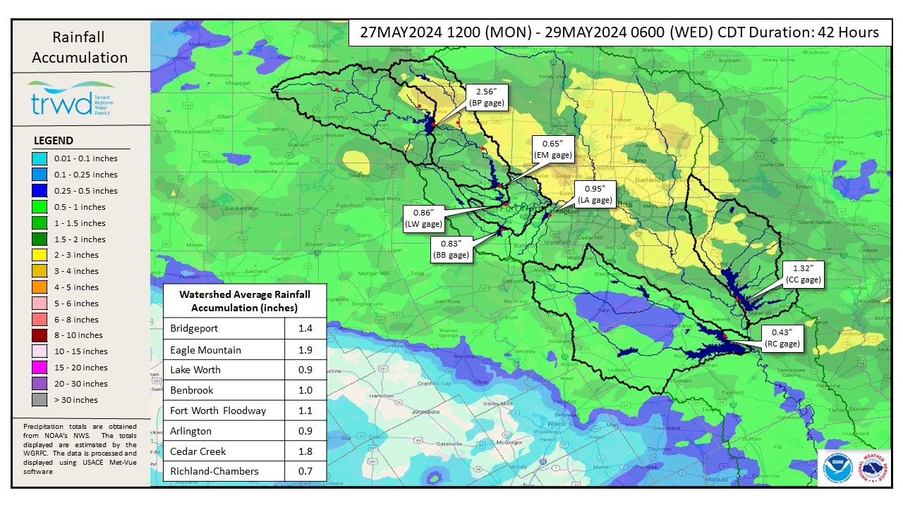
- Total rainfall depths since Monday shown in Graphic-1.
- Light rain in the TRWD service area since last update.
- Eagle Mountain Lake has filled with the rains. Flood discharges to start later today.
- East Texas lakes (Richland-Chambers and Cedar Creek) continue to make flood discharges.
Projections
- Despite flood discharges starting today, Eagle Mountain is expected to rise as runoff from Big Sandy Creek makes its way into the lake.
- This runoff is coming from the 3 to 4″ of rainfall that fell near Alvord yesterday morning.
- Cedar Creek and Richland-Chambers are expected to remain fairly constant with a slight downward trend.
*Projections are subject to change and are based on past precipitation.
Looking Forward
Additional rainfall is expected until Sunday. Some isolated storms are expected today. Severe rainfall potential returns Thursday and Friday. See Graphic-2 and 3 for the latest NWS guidance. Bridgeport is more than 11 ft below conservation and has plenty of room to catch the runoff. The other TRWD lakes are over full. TRWD staff will continue to monitor conditions and flood discharges will be adjusted accordingly.
Please stay weather aware and follow our partners at the National Weather Service (NWS) and the River Forecast Center (RFC) for the latest information regarding weather and river conditions, respectively.
Current TRWD lake conditions are shown below. Be sure to subscribe to receive e-mail notification of any new Lake Level Blog posts. You can also follow @TRWD_News on X (formerly known as Twitter) to receive Lake Level blog notifications.
Next update will come when conditions warrant. Please subscribe or check back when lake levels are on the rise.
Graphic-1. 12-hour Rainfall Totals
Graphic-2. NWS Tuesday Night Guidance
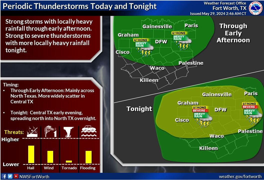
A cluster or complex of showers and thunderstorms, some strong with locally heavy rainfall will move in from the west and impact mainly North Texas later this morning into the early afternoon hours. A brief reprieve occurs later today, before more scattered storms develop initially over Central Texas early this evening, then expand northward into North Texas as well. A few strong to severe storms with large hail and very gusty winds can’t be ruled out. Some heavy rainfall and areas of flooding can be expected.
Graphic-3. NWS Thursday-Friday Guidance
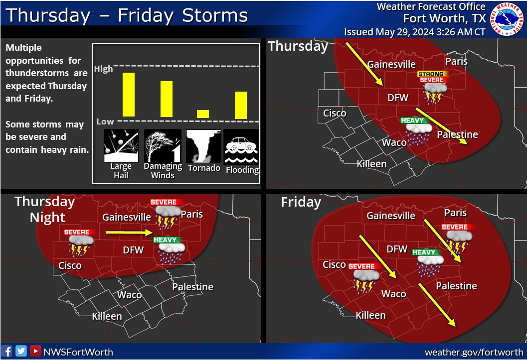
The potential for severe weather will return on Thursday and continue through Friday as multiple rounds of thunderstorms move through the forecast area. Large hail and damaging winds will both be possible, along with heavy rain. The tornado potential appears low at this time, but cannot be completely ruled out.
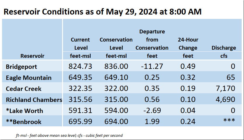
*Lake Worth is owned and operated by the City of Fort Worth. See the City of Fort Worth news feed and NWS forecast page for updates on Lake Worth.
**Benbrook Lake is owned and operated by the U.S. Army Corps of Engineers. ***See Benbrook Lake Home Page for current discharge.
Current lake levels can be found in a variety of locations including TRWD.com, the TRWD watershed data viewer trwd.onerain.com, or download the TRWD Lake Level App for iOS or Android.
Please call the Flood Hotline for further information.
817-720-4296
If prompted to leave a message, the flood monitor on duty will return your message within 30 minutes.
Posted by VdO