No rain in the TRWD lake watersheds yesterday.
Reservoir Operations
*Projections below are based on conditions up to the time of publication. Additional rainfall and spillway operations past the time of publication are not accounted for in these projections.
Cedar Creek – Pool has peaked and will recede through the weekend. Discharges will be reduced as the pool falls.
Richland-Chambers – Pool has peaked. Levels may remain fairly constant today; expect a more defined drop in level this weekend
Reservoir staff is monitoring conditions and will make updates to spillway operations as needed to safely pass the excess flood water and return the reservoir back to conservation elevation. Updates regarding spillway gate changes from TRWD lakes will be posted to the Lake Level Blog as they occur.
Outlook
Outlook for the weekend is warm and breezy, see Graphic 1. Rain returns Monday. This is more of a severe weather threat than it is a flood threat see Graphic 2 for guidance.
This will be the last update for this event. Subscribe or check back for more updates. Stay safe and weather aware!
Follow our partners at the National Weather Service (NWS) and the River Forecast Center (RFC) for the latest information regarding weather and river conditions, respectively.
Current TRWD lake conditions are shown below. Be sure to subscribe to receive e-mail notification of any new Lake Level Blog posts. You can also follow @TRWD_News on X (formerly known as Twitter) to receive Lake Level blog notifications.
Graphic-1. Warm and Breezy Weekend
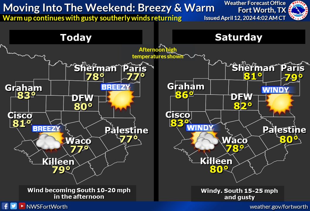
Rain-free weather will prevail into the weekend. Southerly winds will increase by this afternoon to between 10 to 15 mph, then become 15 to 25 mph and gusty on Saturday. Warmer temperatures from the mid 70s to mid 80s will be the rule across the region with a slow increase in humidity during the weekend.
Graphic-2. Severe WX Threat on Monday
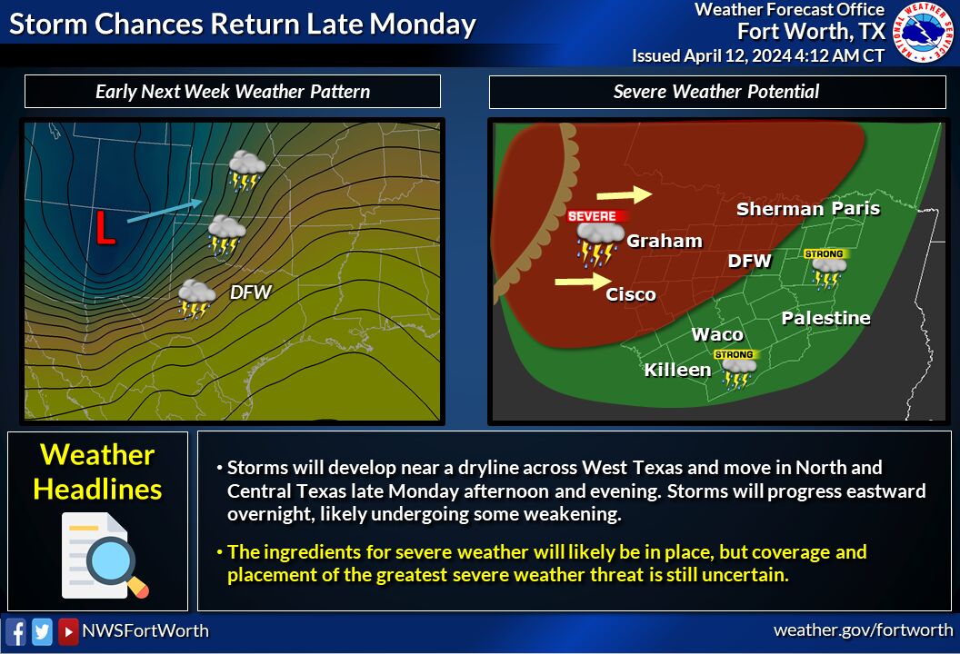
Thunderstorms are expected to develop near a dryline across West Texas late Monday afternoon and move eastward into our area during the evening hours. A few strong to severe storms are possible as they progress through North and Central Texas heading into the overnight hours. More details will be available in the coming days.
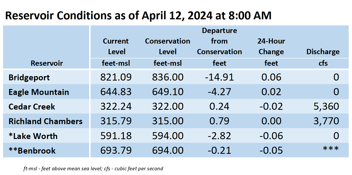
*Lake Worth is owned and operated by the City of Fort Worth. See the City of Fort Worth news feed and NWS forecast page for updates on Lake Worth.
**Benbrook Lake is owned and operated by the U.S. Army Corps of Engineers. ***See Benbrook Lake Home Page for current discharge.
Current lake levels can be found in a variety of locations including TRWD.com, the TRWD watershed data viewer trwd.onerain.com, or download the TRWD Lake Level App for iOS or Android.
Please call the Flood Hotline for further information.
817-720-4296
If prompted to leave a message, the flood monitor on duty will return your message within 30 minutes.
Posted by CO